Educational design research on the combined use of digital geo-media and field work to promote geographic system competence among students.
Development of design principles for digital-analog teaching units using the example of satellite images in the context of the geographic key concepts (working title)
Supervisor: Prof. Dr. Alexander Siegmund
The aim of modern geography lessons is to enable students to understand complex human-environment systems as well as to act responsibly and sustainably. In order to increase the geographical system competence required for this, they have to learn from examples how to understand geographical facts as a system, to analyze them and, based on its modeling, to derive prognoses and recommendations for action. Through the integrated use of digital geo-media such as satellite images and field work, students learn the necessary geographic key concepts and thus increase their system competence. Using satellite images, they analyze large-scale processes in ecosystems and individual elements of these systems in the field. The app “BLIF:Explorer” developed in the "Geo: spektiv2GO"-project at the Department for Geography - Research Group for Earth Observation (rgeo) at the Heidelberg University of Education supports students in these tasks by enabling them to collect geodata on their own. The collected data can then be analyzed with BLIF. The app provides the link between problem and action-oriented analysis of satellite images with BLIF and field work.
For the combined use of these digital-analog approaches in the context of the geographical basic concepts, however, there is a lack of specially designed teaching units and methodical-didactic design principles for the design of such units. The aim of the dissertation project is to determine this using an Educational Design Research (EDR) approach. For this purpose, a prototype is developed using design ideas derived from the literature, which is iteratively optimized with qualitative and quantitative methods with experts, teachers, and students. In this way, empirically validated design principles, for the combined use of digital geo-media using the example of satellite data and field work in the context of the geographic key concepts to increase the geographic system competence of young people, can be found.
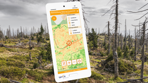
Wirefram of the developed App „BLIF:Explorer”.