Fog climatology at Tarapacá Region in the northern Chilean Atacama Desert –
A multiscale analysis of regional and local fog variability
Supervisor: Prof. Dr. Alexander Siegmund
The coastal Chilean Atacama Desert comprises some of the driest areas of the world, with average annual precipitation partially below 1 mm per year (Westbeld, A., Klemm, O., Grießbaum, F., Sträter, E., Larrain, H., Osses, P. & Cereceda, P., 2009). When penetrating inland the stratocumulus clouds are intercepted by the coastal topography and become an advection fog. This ocean-atmosphere interconnected system determines the the spatio-temporal dynamic of the marine advection fog, providing moisture to a hyper-arid environment and allowing the development of ecosystems and high biodiversity along the Atacama coast (Cereceda, P., Larrain, H., Osses, P., Farías, M. & Egaña, I., 2008).
The aim of this research is to understand fog climatology at Tarapacá region based on two scales, the regional scale covers a representative study area from the coast to ca. 11 km inland desert to analyze the temporal gradient of fog climatology. On a local scale a representative study site called “Oyarbide” has been defined, to analyze and model the spatial gradients and variability of fog for different time scales. The study site is framed by an east/west directed corridor, where the advective and orographic fog can penetrate far enough inland reaching around 1,200 m, where is located one of the largest Tillandsia landbeckii fields in the region, over a range of about 300 m elevation (Cereceda, P., Osses, P., Larrain, H. & Pérez, M.; Westbeld, A., Klemm, O., Grießbaum, F., Sträter, E., Larrain, H., Osses, P. & Cereceda, P., 2009).
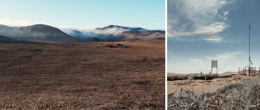 Photo: David Jäger